User Tools
Sidebar
start
Weather Radar and Alerts
Version 1 will be no longer supported after May 1st, 2025. Version 2 BETA will be released in March of 2025, and expected release in Windows store in May of 2025. (See [[change log]] for more)
Getting Started
First, we want to thank you for using Weather Radar and Alerts. If you need any help, head over to our community or use our support system.
Weather Radar and Alerts is powerful enough for weather enthusiast, but simple enough for the every day user wanting to gain information about the current weather. The application is designed to be usable directly from installation, but there are a few layers and settings you might want to change.
Home Alert
The initial aspect of this application that should get mentioned is the Home Alerts. Home Alerts allows the user to select a location on the map. If a Tornado Warning or Sever Thunderstorm Warning is issued for this location, the application will alert the user by sound and a pop-up. The current method the application alerts the user is based on County, State. A future update will change this to Latitude and Longitude, making this feature even more accurate.
Please remember, this is a tool. Please don't rely on this application alone to keep you and your family safe as it relies on the internet, power, etc. You should also monitor local news, national weather channels, and even have a NOAA weather radio.
Currently, new warnings are pulled from the National Weather Service servers every 20 seconds.
NOTE: Turning off warnings will disable Home Alerts.
For additional information about Home Alert, check out the Home Alerts page.
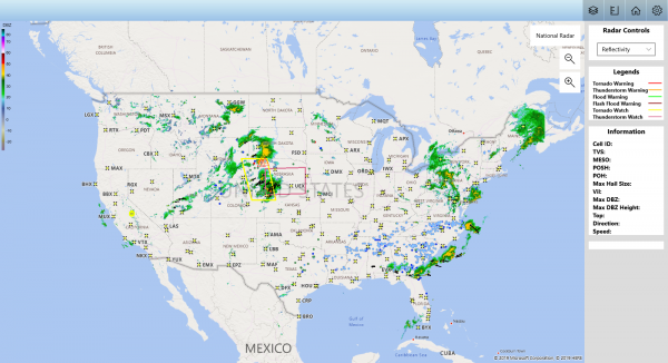
Radar
The application has several different types of Radar and Modes to view. The initial radar when the application is opened is the National Radar (USCOMP). This radar view is generated by combining the 130+ individual RADARs that comprise the NEXRAD network.
Additionally, the application has markers for each radar. There are two different radar types that are displayed on the map. Those radar types are:
- NEXRAD (WSR-88D)
- TDWR
Clicking a single radar will zoom to that location and display the initial radar view (Reflectivity, High Resolution). Additionally, you can change the radar view to other types/products.
For additional information about the Radar, check out the Radar page.
Layers
Layers are the objects that are displayed on the map. This includes the following layers:
- Radar
- Warnings
- Watches
- Storm Attributes
- Storm Reports
Additional Layers are expected to be released with future versions.
For additional information about the Layers, check out the Layers page.
Measuring Tool
The measuring tool allows the user to set the speed of the storm and click between two locations. This will result in a pop-up displaying the estimated time of arrival.
For additional information about the Measuring Tool, check out the Measuring Tool page.
start.txt · Last modified: 2025/01/31 00:04 by admin
Page Tools
Except where otherwise noted, content on this wiki is licensed under the following license: GNU Free Documentation License 1.3
